Auckland’s story spans more than 700 years and covers some of the most dramatic chapters in New Zealand’s history — Māori settlement of the Tāmaki Makaurau isthmus around 1350, the construction of fortified pā on dozens of volcanic cones, the signing of Te Tiriti o Waitangi (the Treaty of Waitangi) on Manukau Harbour in 1840, the founding of colonial Auckland on Ngāti Whātua land, and the 20th-century evolution into the diverse Pacific city of today. This complete history of Auckland guide walks you through the timeline — from Māori arrival to modern Tāmaki Makaurau — with the historical sites and museums where you can engage with the story directly.

The volcanic landscape
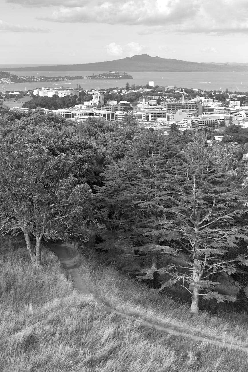
Auckland’s geography defines its history. The isthmus sits on the Auckland Volcanic Field, with 53 volcanic centres spread across the city — most dormant, none currently active, but all geologically young. Rangitoto Island, the iconic cone visible from every Auckland beach, erupted only 600 years ago. The volcanic cones gave the area exceptional fertility (volcanic soils support intensive horticulture) and exceptional defensive value (the cones provided natural fortified positions). Both qualities shaped Tāmaki’s pre-European history.
The narrowness of the Tāmaki isthmus is also strategically critical. The Tasman Sea lies just kilometres west; the Hauraki Gulf and Pacific Ocean to the east. Two harbours — the Waitematā (north and east) and the Manukau (south and west) — create exceptional natural ports with seafood, shellfish, and protected anchorages. This combination of soils, coastlines and volcanoes made Tāmaki one of Aotearoa’s most desirable places to live for centuries.
Māori settlement (1350-1840)
Tāmaki Makaurau — “Tāmaki desired by many”
Māori arrived in Aotearoa around 1280, descended from Polynesian settlers from the wider Pacific. Tāmaki itself was settled by approximately 1350. The name Tāmaki Makaurau means “Tāmaki desired by many” — referring to the area’s exceptional natural resources and the constant inter-iwi competition for control. Multiple iwi (tribes) settled the region over centuries, including Te Wai-o-hua, Ngāti Whātua, Ngāti Pāoa and the Ngāti Maru hapū.
Volcanic pā and intensive horticulture
From 1600 to 1750 the Tāmaki tribes terraced the volcanic cones, building fortified pā on Maungawhau (Mt Eden), Maungakiekie (One Tree Hill), Maungarei (Mt Wellington), Rangitoto, and dozens more. The largest pā at Maungakiekie/One Tree Hill housed an estimated 10,000+ people at its peak. Across the isthmus the Tāmaki iwi developed 2,000 hectares of kūmara gardens (the sweet potato was the staple crop), rua kūmara (food storage pits), and stone walls for crop protection.
At the peak of pre-European prosperity around 1750, the population numbered tens of thousands — making Tāmaki one of the most densely settled regions in pre-contact Aotearoa. The volcanic cones and surrounding land were intensively managed for food production, ceremonial protocol, and military defence.
Tribal conflicts and population shifts
From the early 18th century, Ngāti Pāoa expanded into the Hauraki Gulf and as far north as Mahurangi. Between 1740-1750 Ngāti Whātua-o-Kaipara moved south, invading the isthmus and killing Kiwi Tāmaki, paramount chief of Te Waiohua. Ngāti Whātua then took his last pā at Māngere. The two tribes secured their dominance of the isthmus by intermarrying with descendants of the Waiohua. By 1800, Ngāti Whātua-o-Ōrākei (a Ngāti Whātua hapū) was the dominant iwi on the central isthmus.
The Musket Wars (1810-1840) — a period of intertribal conflict driven by the arrival of muskets through European trade — devastated Tāmaki. By 1840, Ngāti Whātua-o-Ōrākei retained control of the central isthmus but had been dramatically reduced in numbers. Many former pā sites were abandoned. The arrival of European settlers would soon transform the demographic and political landscape.
European arrival and the Treaty (1769-1840)
Cook’s voyages
European contact with Aotearoa began with Captain James Cook’s voyages of 1769, 1773 and 1777. Cook didn’t enter the Tāmaki isthmus directly, but his expeditions opened Aotearoa to European traders, missionaries and whalers. From 1810, sealers and whalers visited the Hauraki Gulf, and Christian missionaries arrived in the Bay of Islands (north of Auckland) from 1814. By the 1830s, English and Australian whalers were visiting Auckland’s Waitematā Harbour annually.
The Treaty of Waitangi
The Treaty of Waitangi was signed at Waitangi on 6 February 1840, establishing Aotearoa as a British colony with explicit guarantees of Māori land ownership and chiefly authority. Multiple Māori chiefs signed the Treaty over the following months. On 20 March 1840, in the Manukau Harbour area where Ngāti Whātua farmed, paramount chief Apihai Te Kawau signed Te Tiriti o Waitangi (the te reo Māori translation of the Treaty).
Soon after signing Te Tiriti, Ngāti Whātua Ōrākei (the primary hapū and landowner in Tāmaki Makaurau) made a tuku (strategic gift) of 3,500 acres (1,400 hectares) of land on the Waitematā Harbour to Governor William Hobson — the new Governor of New Zealand — for the new colonial capital.
Colonial Auckland (1840-1900)

Founding of Auckland
The official founding ceremony took place on 1 September 1840. Governor Hobson named the city after George Eden, 1st Earl of Auckland — his patron and a former Auckland Viceroy of India. The Union Jack was raised on Point Britomart (now Britomart precinct), and Auckland became the colonial capital of New Zealand.
Initial settlement was concentrated around the Waitematā Harbour foreshore, with the original township covering modern-day Britomart, Quay Street, and the lower CBD. Government buildings, the original Anglican cathedral (1843), and the first wharf were built in this area. The population grew from 2,000 in 1841 to 8,000 in 1851.
Land alienation and the New Zealand Wars
As the Māori population declined for nearly a century, so did the quantity of land held by Ngāti Whātua. Within 20 years, 40% of their lands were lost — some through Government land confiscation, some through dubious purchase agreements, and some through tax-related forced sales. The land confiscations escalated during the New Zealand Wars (1845-1872), particularly the Waikato Wars (1863-1864), when government forces invaded Waikato to break Māori political authority. Auckland was the colonial military base for these wars.
Ngāti Whātua-o-Ōrākei, in particular, lost the great majority of their land through the second half of the 19th century. The remaining sliver of Ngāti Whātua land at Bastion Point (Ōrākei) became a flashpoint a century later — the 1977-1978 Bastion Point occupation, where Ngāti Whātua and supporters occupied the disputed land for 506 days, ultimately securing partial restitution.
Loss of capital status
In 1865, Wellington was made the new capital of New Zealand for its more central geographical position. Auckland lost capital status but kept its status as the country’s largest city. The transition shaped the city’s character — Auckland became commercial and pragmatic rather than political, with strong ties to international trade through the Waitematā Harbour.
Victorian growth
The second half of the 19th century saw rapid growth. Heritage suburbs like Parnell (founded 1841), Ponsonby (1880s), Devonport (1860s), and Newmarket (1880s) developed. The Auckland Harbour Bridge wouldn’t be built until 1959, so Devonport residents commuted via ferry to the CBD. The Auckland Domain (1840) and Cornwall Park (1903) became the city’s flagship parks. Auckland Museum’s first incarnation opened in 1852, making it one of the oldest museums in the country.
Modern Auckland (1900-2000)
Pacific migration and demographic transformation
The 20th century transformed Auckland into a multicultural city. From the 1950s, Pacific Island immigration became significant — Samoans, Tongans, Cook Islanders, Niueans and Tuvaluans arrived for work in the post-war industrial economy. By 2000, Auckland had become home to the largest Polynesian population of any city in the world. Asian immigration accelerated from the 1990s, particularly from China, India, and Korea. Today Auckland’s population is roughly 50% European, 17% Asian, 15% Pasifika, 11% Māori, and 7% other (including Middle Eastern and African communities).
Auckland Harbour Bridge and post-war infrastructure
The Auckland Harbour Bridge opened in 1959, finally connecting the North Shore to the central isthmus by road. The bridge fundamentally reshaped Auckland’s geography — the North Shore became a fully integrated suburb of the city, the population spread north, and Devonport’s ferry-only character gave way to a fully connected suburb. The Bridge’s construction was followed by major motorway development through the 1960s and 1970s, and the Auckland International Airport (opened 1965, expanded multiple times since).
The Bastion Point occupation
In 1977-1978, Ngāti Whātua-o-Ōrākei and supporters occupied Bastion Point — disputed land in eastern Auckland — for 506 days. The occupation became one of the defining moments in the modern Māori cultural and political revival, and led to partial land restitution and broader Treaty of Waitangi settlement processes through the 1980s and 1990s. Today Bastion Point is co-managed by Auckland Council and Ngāti Whātua Ōrākei; the suburb of Ōrākei sits adjacent.
Sky Tower and modern landmarks
The Sky Tower opened in 1997, instantly becoming Auckland’s defining landmark — at 328 metres, the tallest free-standing structure in the Southern Hemisphere. SkyCity casino opened the same year. Auckland Art Gallery’s modern extension (2011) and the Auckland Museum’s dome atrium (2007) followed. The Britomart Transport Centre and Britomart Precinct redevelopment (2003-2010) transformed the lower CBD into the city’s most polished retail and dining district.
Auckland’s pā sites today
The fortified pā that defined pre-European Tāmaki are still visible on most of Auckland’s volcanic cones. The terraces, kūmara storage pits, and stone walls — built between 1500 and 1750 — remain partially intact across multiple sites:
- Maungakiekie / One Tree Hill — the largest pā at peak; complex terracing system visible on the slopes; multiple ditches and bank fortifications.
- Maungawhau / Mt Eden — 360° city-view pā site with extensive terraces.
- Maungarei / Mt Wellington — the most-intact pā terracing; less visited than Mt Eden.
- Rangitoto Island — volcanic cone with pre-European Māori sites (now protected nature reserve).
- Mōtutapu Island — adjacent to Rangitoto; significant pre-European Māori archaeological sites.
- Maungauika / North Head (Devonport) — later 19th-century military fortification incorporated into earlier pā site.
- Takarunga / Mt Victoria (Devonport) — hilltop pā with views across Waitematā Harbour.
- Maungauika / North Head (Devonport) — military and pre-European cultural significance.
Auckland Council provides interpretive panels at the major pā sites explaining their pre-European context. The walks to the summits of Mt Eden, One Tree Hill, and Mt Victoria all pass through preserved pā terracing — they’re free, accessible, and one of the most direct ways to engage with pre-European Tāmaki history.
Notable Auckland figures throughout history
- Apihai Te Kawau — paramount chief of Ngāti Whātua-o-Ōrākei, signed Te Tiriti at Manukau Harbour on 20 March 1840 and made the tuku of land that founded Auckland.
- William Hobson — first Governor of New Zealand (1840-1842); founder of colonial Auckland; namesake of Hobson Street and the wider Hobson Bay area.
- George Eden, 1st Earl of Auckland — the city’s namesake; British politician who never visited but had been Hobson’s patron.
- Sir John Logan Campbell — “Father of Auckland”; settler, businessman, and benefactor who donated Cornwall Park and One Tree Hill to the city in 1903.
- Sir Apirana Ngata — Māori politician and academic who lived in Auckland and championed Māori cultural revival.
- Joe Hawke — Ngāti Whātua leader who organised the 1977-78 Bastion Point occupation.
- Sir Edmund Hillary — Auckland-born mountaineer who became the first to summit Everest with Tenzing Norgay in 1953.
- Sir Peter Blake — Auckland sailor who led NZ to America’s Cup victories in 1995 and 2000; established Auckland’s “City of Sails” reputation.
- Lorde — contemporary Auckland-born artist who put modern Auckland on the international cultural map.
21st-century Auckland

The 2010s and 2020s have continued to reshape Auckland. The 2010 amalgamation of seven separate councils into the unified Auckland Council created a single super-city governance structure. The Wynyard Quarter waterfront redevelopment (2010-2019) transformed disused industrial silos into a popular public precinct. Cultural and Pacific celebrations — Pasifika Festival, the Auckland Lantern Festival, Auckland Pride — became major annual events drawing hundreds of thousands of visitors.
The 2026 City Rail Link opening (the country’s largest infrastructure project ever) marks the next chapter — a 3.5 km underground rail tunnel through the CBD with two new stations, doubling rail capacity. By 2030, Auckland Transport plans to have a fully battery-electric bus fleet. The city continues to evolve as Aotearoa’s largest, most diverse, and most-visited urban centre.
Auckland’s place names and what they mean
Auckland’s place names carry layers of history. Many neighbourhood names are Māori (Maungawhau, Pukekawa, Waitematā, Manukau, Karangahape) while others are British colonial (Auckland, Devonport, Greenlane, Mt Albert). Some have both Māori and English names that visitors should learn:
- Tāmaki Makaurau — “Tāmaki desired by many”; the Māori name for the Auckland region.
- Maungawhau — “the mountain of the Whau tree”; English name Mt Eden.
- Maungakiekie — “the mountain of the kiekie vine”; English name One Tree Hill.
- Pukekawa — “hill of bitter memories”; English name Auckland Domain.
- Maungarei — “the watchful mountain”; English name Mt Wellington.
- Rangitoto — “blood-red sky”; the volcanic island.
- Waitematā — “obsidian water”; the northern harbour.
- Manukau — “place of the wading bird”; the southern harbour.
- Karangahape — “the calling place of Hape”; the cross-CBD road.
- Ōrākei — “the place of the wreath”; the eastern suburb where Ngāti Whātua-o-Ōrākei reside.
- Mōtutapu — “sacred island”; one of the Hauraki Gulf islands.
Auckland Council’s Te Ahumairangi (Māori names) project has expanded the use of Māori names on signage, transport, and council communications since 2016. Increasingly, Auckland visitors will encounter both names side-by-side at major sites.
Auckland’s historical sites for visitors
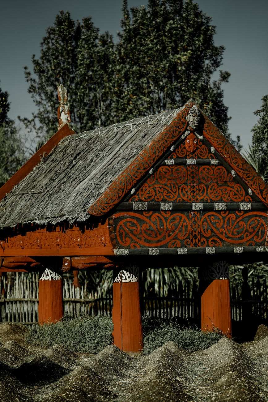
- Auckland War Memorial Museum — Māori taonga, Pacific Lifeways, war memorial; the city’s most important historical institution.
- Maungawhau / Mt Eden — volcanic cone with terraced pā remains; 360° city views from the summit.
- Maungakiekie / One Tree Hill — the largest pā at peak; Cornwall Park surrounds the cone.
- Auckland Domain — the city’s oldest park (1840); Wintergardens; museum on summit of Pukekawa volcanic cone.
- Bastion Point / Ōrākei — Ngāti Whātua land restitution site; clifftop views of Rangitoto.
- Britomart precinct — heritage warehouses where Auckland’s colonial founding occurred.
- St Mary’s-in-Holy Trinity Church (Parnell) — 1849 wooden Gothic church; one of the city’s oldest buildings.
- Holy Trinity Cathedral (Parnell) — world’s only Polynesian Gothic cathedral.
- Devonport Naval Museum — military and naval heritage on the North Shore.
- Auckland Maritime Museum (Viaduct) — Pacific voyaging, colonial maritime history.
- Auckland Art Gallery Toi o Tāmaki — NZ historic and contemporary art.
- Howick Historical Village — 1840s settler village preserved as outdoor museum.
- Awhitu Heritage Trail — Auckland Council’s heritage drive south of the city.
- Auckland Heritage Festival — two weeks of free heritage events each March.
Books and resources for deeper history
- From Tāmaki-Makaurau-Rau to Auckland by R. C. J. Stone — the most comprehensive history of Auckland; available at Auckland Libraries.
- Auckland Museum’s Te Ara online resources — free history articles at teara.govt.nz with Auckland-specific content.
- The People of Tāmaki Makaurau by Ngarino Ellis — Māori historical context.
- Auckland Heritage Festival programme — annually published guide to free heritage events.
- NZHistory.govt.nz — government heritage portal with Auckland-specific content.
- Auckland Council’s heritage maps — free downloadable walking maps for Parnell, Devonport, and Onehunga.
- Pourere Stone Database — Auckland Museum’s online archive of pā site research.
A Tāmaki Makaurau cultural day
- 9:00am — Auckland Museum (free for Aucklanders; $32 international). Focus on the Māori Court and the world-class Te Toki a Tāpiri waka.
- 11:00am — Māori cultural performance at the museum (combined ticket $55).
- 12:00pm — Walk down through Auckland Domain to the Wintergardens.
- 12:30pm — Lunch at Wintergarden Café or Cibo (Parnell).
- 2:00pm — Holy Trinity Cathedral and St Mary’s-in-Holy Trinity (free).
- 3:00pm — Drive to Maungawhau (Mt Eden) summit for views and the volcanic crater.
- 4:00pm — Drive to Bastion Point for sunset views over the Waitematā Harbour.
- 6:00pm — Dinner in Britomart at kingi (Hotel Britomart) — fittingly, on the site of Auckland’s colonial founding.
Key dates in Auckland’s timeline
- ~1280 — Polynesian arrival in Aotearoa.
- ~1350 — Māori settlement of Tāmaki Makaurau begins.
- ~1500-1750 — Volcanic pā construction; population peaks at tens of thousands.
- ~1740-1750 — Ngāti Whātua establish dominance on the isthmus.
- 1810-1840 — Musket Wars devastate Tāmaki Māori populations.
- 1769-1777 — Cook’s voyages bring European contact.
- 6 February 1840 — Treaty of Waitangi signed at Waitangi.
- 20 March 1840 — Apihai Te Kawau signs Te Tiriti at Manukau Harbour.
- 1 September 1840 — Founding of colonial Auckland.
- 1843 — First Anglican cathedral.
- 1845-1872 — New Zealand Wars; Auckland is colonial military base.
- 1852 — Auckland Museum founded.
- 1865 — Wellington becomes capital; Auckland loses capital status.
- 1888 — Auckland Art Gallery opens.
- 1903 — Cornwall Park opens.
- 1929 — Auckland War Memorial Museum building opens.
- 1959 — Auckland Harbour Bridge opens.
- 1965 — Auckland International Airport opens.
- 1977-78 — Bastion Point occupation.
- 1997 — Sky Tower opens.
- 2003-2010 — Britomart precinct redevelopment.
- 2010 — Auckland Council amalgamation.
- 2010-2019 — Wynyard Quarter waterfront redevelopment.
- 2026 — City Rail Link opens (planned).
FAQs
When was Auckland founded?
1 September 1840, when Governor William Hobson raised the Union Jack on Point Britomart. The site was a tuku (strategic gift) from Ngāti Whātua Ōrākei to the new colony.
What does Tāmaki Makaurau mean?
“Tāmaki desired by many” — referring to the area’s exceptional natural resources and the constant inter-iwi competition for control over the centuries.
When did Māori first settle Auckland?
Around 1350. Polynesian voyagers had arrived in Aotearoa around 1280, and the Tāmaki isthmus was settled by the major iwi within the following century.
How many volcanoes does Auckland sit on?
53 volcanic centres make up the Auckland Volcanic Field. Most are dormant; the most recent eruption was Rangitoto Island around 600 years ago.
Was Auckland always the capital of New Zealand?
No — Auckland was the colonial capital from 1840 to 1865. Wellington was made the new capital in 1865 for its more central geographical position. Auckland kept its status as the country’s largest city.
Where can I learn more about Auckland’s Māori history?
Auckland War Memorial Museum’s Māori Court is the country’s best collection of Māori taonga. The volcanic pā sites at Maungawhau (Mt Eden) and Maungakiekie (One Tree Hill) preserve pre-European pā architecture. Bastion Point tells the story of post-Treaty land restitution.
When did the Sky Tower open?
1997. At 328 metres it remains the tallest free-standing structure in the Southern Hemisphere.
When did the Auckland Harbour Bridge open?
1959, with major capacity expansion clip-ons added in 1969.
What was the Bastion Point occupation?
A 506-day occupation by Ngāti Whātua and supporters in 1977-1978, protesting government land seizures from Ngāti Whātua Ōrākei. The occupation led to land restitution and shaped modern Treaty of Waitangi settlement processes.
Why is Auckland called the “City of Sails”?
For its high boat ownership per capita and the iconic America’s Cup yachting heritage. Auckland has the most boats per capita of any major city — roughly 1 boat for every 4 households.
What is the largest historical building in Auckland?
Auckland War Memorial Museum (1929) is the city’s most architecturally significant historical building — a neoclassical structure on the summit of the Pukekawa volcanic cone in Auckland Domain.
Tips for engaging with Auckland’s history
- Start at the Auckland Museum’s Māori Court — it’s the city’s most important historical institution.
- Visit volcanic cones (Mt Eden, One Tree Hill) at sunset for atmospheric pā-site experiences.
- Take the Auckland Heritage Festival’s free walks each March for guided historical experiences.
- Read about Te Tiriti o Waitangi before visiting; the Auckland Maritime Museum’s Pacific voyaging gallery contextualises Māori arrival.
- Combine Auckland Museum + Bastion Point + Mt Eden in a single half-day for a complete pre-European historical picture.
- Auckland Art Gallery’s Lindauer portrait collection adds 19th-century cultural-historical depth.
- The Howick Historical Village (East Auckland) recreates 1840s European settler life — worth a half-day.
- Many Auckland streets have Māori names — learn 5-10 before you visit (Maungawhau, Maungakiekie, Tāmaki, Waitematā, Manukau).
- The Bastion Point lookout has interpretive panels explaining the 1977-78 occupation.
- Local guides for Tāmaki cultural tours can be booked through Auckland Museum.
The bottom line
Auckland’s history is more layered than most visitors expect — 700+ years of Māori settlement, dramatic intertribal conflicts, the Treaty of Waitangi, colonial founding, the New Zealand Wars, Pacific migration, and modern Aotearoa identity all overlapping on the volcanic isthmus. Engaging with this history through Auckland Museum, the volcanic pā sites, and Bastion Point gives any Auckland visit far more depth.
Plan more cultural experiences with our complete Auckland culture, history & Māori heritage pillar, our Auckland Museum guide, and our Auckland Museum Māori exhibits deep-dive. Pair this with our Parnell neighbourhood guide for the Victorian heritage walking experience.