Auckland is the only major city on Earth built on a dormant volcanic field, flanked by two different oceans, and wrapped in temperate rainforest. That geography is the gift: within 45 minutes of the CBD you can swim at a calm white-sand harbour beach, surf a wild black-sand Tasman break, hike across a 600-year-old volcano, or walk a subtropical forest trail under nikau palms. This guide ranks Auckland’s best beaches by what you actually want to do — swim, surf, walk, take kids, watch wildlife, eat lunch afterwards — and pairs them with the outdoor adventures that make the region one of the most active tourist cities anywhere.
Two coasts, two completely different beach experiences
Auckland sits on a narrow isthmus between the Waitematā Harbour (Pacific / Hauraki Gulf side) and the Manukau Harbour (Tasman Sea side). This single fact shapes every beach decision you’ll make. The east coast — St Heliers, Mission Bay, Takapuna, Long Bay, Kohimarama, Cheltenham, Omaha — faces sheltered gulf water. Waves are small, currents manageable, the sand is pale gold, and parking is a short walk from cafés. These are swimming beaches, family beaches, sunset-drink beaches. The west coast — Piha, Karekare, Muriwai, Bethells, Whatipu — faces the open Tasman. Black iron-rich sand, big surf, strong rips, no cafés, minimal cell coverage. These are surfing beaches, photography beaches, hiking beaches. Many visitors assume “beach day” means either/or; the truth is that Auckland rewards you for doing both. Drive to Piha in the morning, cool off at Mission Bay in the afternoon.
Safety first: rips, tides, and why the west coast kills people every summer
Auckland’s west coast beaches have patrolled flags between October and April, and you must swim between them. The Tasman surf creates permanent rip currents that funnel even strong swimmers offshore within seconds. In 2024, Surf Life Saving Northern Region performed 1,600+ rescues at west coast beaches; the common thread in fatalities is almost always swimming outside patrolled hours or outside the flags. If you are caught in a rip: don’t fight it, float, raise one arm, wait for help or let the rip carry you past the breakers before swimming sideways across the current. Piha, Karekare, Muriwai and Bethells are patrolled daily in summer (usually 10am–6pm); outside those times, don’t go past your knees. Check safeswim.org.nz on the morning of your visit — it has live water-quality, rip, and surf condition ratings for every Auckland beach.
East coast beaches are far safer but not risk-free. The main hazards are stingrays in shallow warm water (shuffle your feet in summer), occasional bluebottle jellyfish washed up by easterly winds, and bacterial contamination after heavy rain. Never swim in any Auckland beach within 48 hours of heavy rain — stormwater runoff regularly pushes E. coli above safe levels, especially at Mission Bay, Cox’s Bay, Judge’s Bay and Weymouth. Safeswim flags these in real time.
The east coast: Auckland’s swimming beaches
Mission Bay
Ten minutes from the CBD along Tamaki Drive, Mission Bay is Auckland’s most central urban beach. The 400m arc of gentle sand faces Rangitoto Island, there’s a shaded promenade with a heritage fountain, and 30+ cafés, restaurants and gelato counters sit directly across the road. It gets crowded on summer weekends but remains the single best choice for visitors without a car: Link bus 781 from downtown runs every 15 minutes. Swimming is safe at high tide; at low tide the water retreats a long way and you’ll want shoes for the shell fragments.
St Heliers
Two minutes further east, St Heliers is Mission Bay’s quieter, more upmarket cousin. The beach is slightly longer, the village has better coffee, and the view across to Rangitoto is arguably cleaner. Free parking is easier than Mission Bay. St Heliers is our pick for a sunset swim: west-facing into the harbour gives you the Sky Tower skyline behind you as the light goes pink.
Kohimarama
Between Mission Bay and St Heliers, Kohimarama is the quieter middle sibling and where locals with young kids actually go. The sand is wider than Mission Bay, water stays calm, and there’s a good playground behind the sea wall. Less food within walking distance but fewer crowds.
Takapuna
North Shore’s answer to Mission Bay, reached via ferry to Devonport plus a 15-minute drive, or bus NX1 then transfer. Takapuna Beach is a long stretch of fine white sand directly under the silhouette of Rangitoto — arguably the best beach view in Auckland. The village behind has a Sunday farmers’ market (8am–noon), strong café scene, and one of the city’s best dinner strips. Hurstmere Road restaurants will happily take a post-swim booking.
Cheltenham and Narrow Neck
On the Devonport peninsula, Cheltenham is sheltered, shallow, and perfect for small children. Narrow Neck, a kilometre around the corner, has a gorgeous grassy reserve, clean flat sand, and direct views of Rangitoto. Both are 15 minutes’ walk from the Devonport ferry wharf — genuinely achievable as a car-free beach trip from downtown.
Long Bay
Thirty minutes north of the CBD at the top of the Northern Motorway, Long Bay is Auckland’s largest regional beach park. The beach itself is 1km of pale sand with a grassy picnic area, playground, BBQs and a shallow entry safe for kids. It’s also the start of the Long Bay–Okura Walkway, a 5km coastal track to one of the region’s best marine reserves. Long Bay is our top pick for a picnic-plus-beach day, and parking is plentiful.
Orewa
Forty minutes north, Orewa is a 3km beach town with proper swimming surf (gentle, east-coast-friendly), a pedestrianised main street, and the Hibiscus Coast café scene. Popular with families staying in holiday parks; good stop on the drive to Matakana.
Omaha
An hour north, Omaha is the East-Coast Bays version of the Hamptons — white sand, designer beach houses, a protected estuary on one side and open ocean on the other. The beach itself is 4km of fine sand with gentle surf; it’s patrolled in summer, and the lagoon behind the beach is calm enough for paddleboarding with toddlers. Combine with Matakana Village (10 minutes inland) for a complete day.
Tawharanui
Ninety minutes north, inside Tawharanui Regional Park, this is arguably the single most beautiful beach in the Auckland region — a 2km white sand arc inside a predator-fenced marine reserve. The surf is gentle, the water is clear enough for snorkelling, and the park behind is full of birdlife you won’t see elsewhere. Day-use free; camping by booking only. Allow a full day.
Pakiri
Fifteen minutes past Omaha, Pakiri is a 14km strip of white sand with almost nobody on it. The water is a shade warmer than the bays closer to the city and the surf is small but rideable. Pakiri Beach Horse Rides runs 90-minute, 3-hour and overnight beach rides year-round from the south end — one of the signature Auckland experiences for travellers who want something beyond the city bus loop.
Goat Island (Leigh)
Near Pakiri, Goat Island Marine Reserve (Cape Rodney–Okakari Point) is New Zealand’s oldest marine reserve, established 1975. The water is so clear and the fish so abundant that wading in to knee-depth will have snapper and blue maomao swimming around your ankles. Hire snorkel gear from Goat Island Dive next to the beach (≈$30/day) and swim 30m offshore to see kingfish, crayfish in crevices, and (in summer) occasional stingrays. This is the best shore-based snorkelling within easy reach of Auckland; allow a full day with the drive.
Maraetai and Kawakawa Bay
Forty-five minutes southeast of the CBD, Maraetai is the east-side equivalent of Mission Bay but with almost no tourists. Shallow sandy swimming bay, view across to the Hauraki Gulf islands, friendly fish-and-chip shop, plus the pohutukawa-lined drive around to Kawakawa Bay is one of the most scenic coastal drives in greater Auckland. Kawakawa itself is quieter and best at mid-to-high tide.
The west coast: Auckland’s surf and wild-beauty beaches
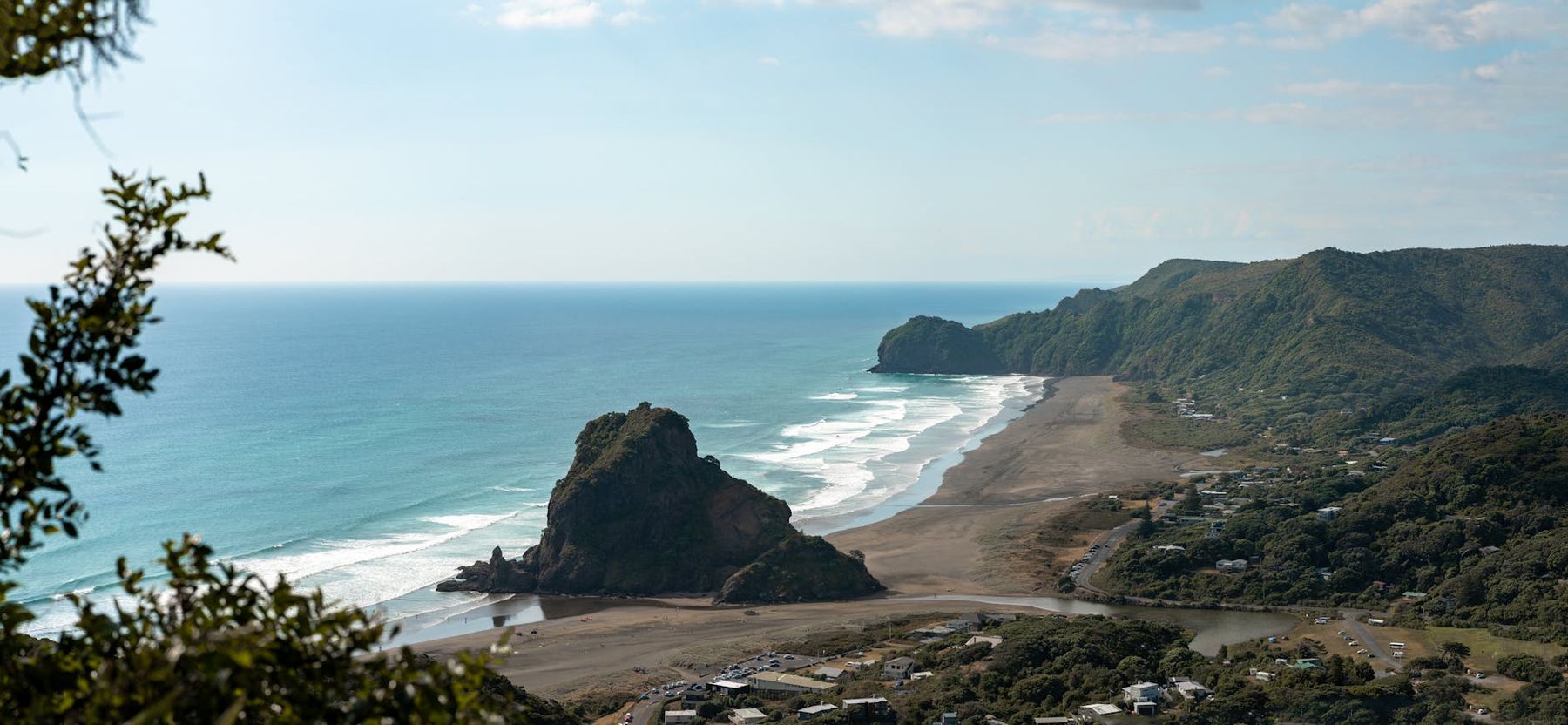
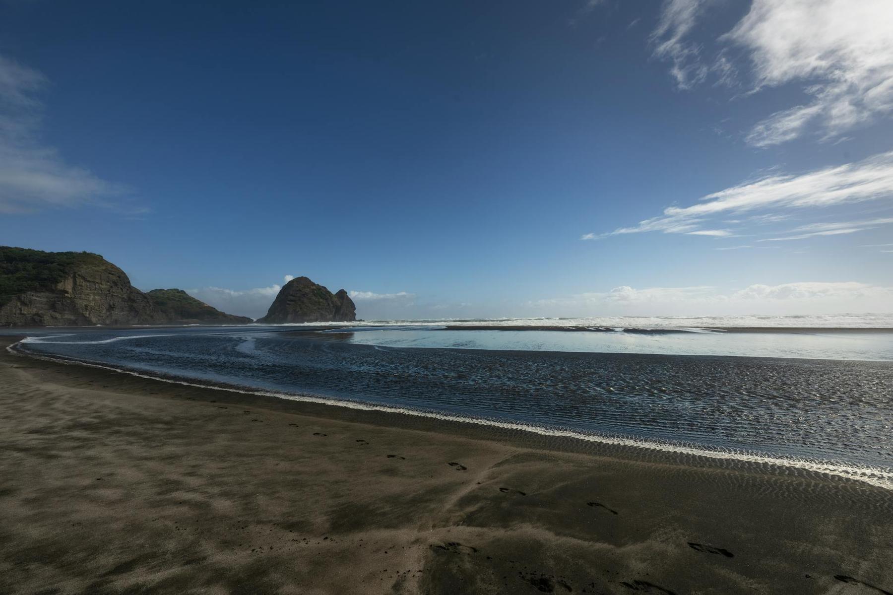
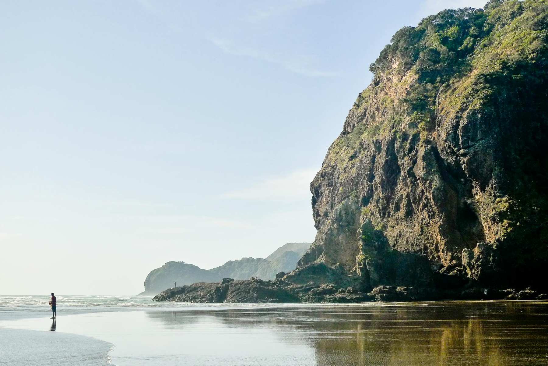
Piha
Forty-five minutes west of the CBD via the Scenic Drive, Piha is the most famous beach in New Zealand. Two kilometres of black iron-sand split by Lion Rock, a 101m-tall volcanic plug you can walk around the base of (the summit track has been closed since 2018 pending track stabilisation; check Auckland Council updates). The north end — North Piha — is quieter and has the Kitekite Falls trail (45-minute one-way through native bush to a tiered 40m waterfall, one of the best short walks in Auckland). Piha has a café, surf school (Piha Surf School offers 2-hour group lessons ≈$90 including board and wetsuit) and a surf club patrolling in summer. Swimming is only safe between the flags. A small shop sells coffee, pies and essentials; otherwise bring supplies.
Karekare
The quiet twin of Piha, 10 minutes south down a steep winding road. Karekare was the filming location for The Piano (1993) and arguably has the more dramatic landscape: a broad black-sand plain, a massive rolling dune behind, and the 20m Karekare Falls just a 5-minute walk from the car park. There are no shops or cafés — pack everything. The beach is patrolled in summer but far less crowded than Piha. Perfect for photographers; acceptable for strong surfers who want fewer people in the lineup.
Muriwai
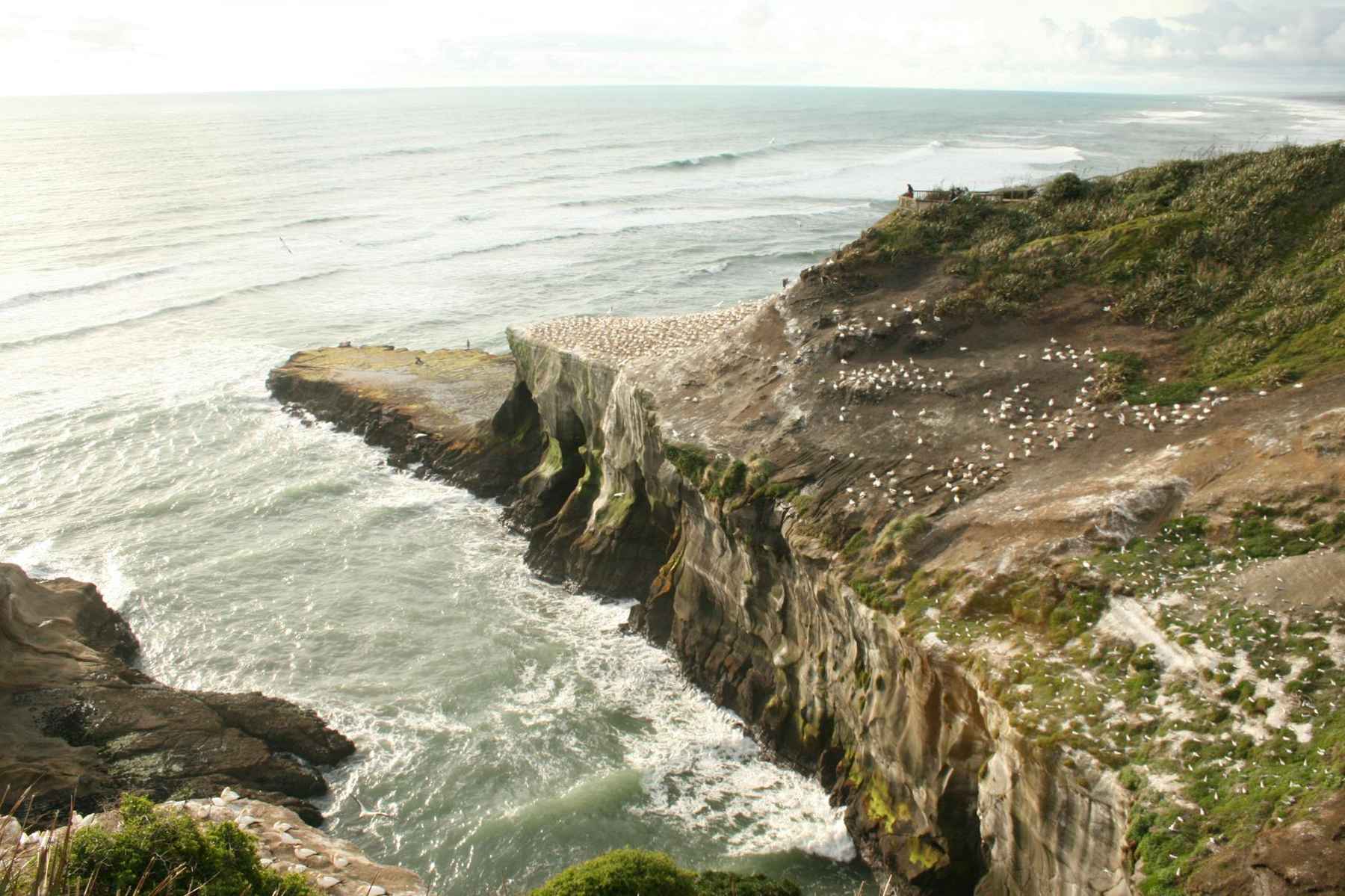
Forty minutes northwest, Muriwai is best known for its gannet colony — 1,200+ breeding pairs of Australasian gannets (takapu) nest on the cliffs from August through March. Two viewing platforms sit directly above the birds; fly-bys pass within metres. The beach itself stretches 60km north, the longest unbroken beach in Auckland. Muriwai is patrolled in summer and hosts the long-running Muriwai Surf Club. The village has a café at the surf club and a golf course with one of the country’s most scenic coastal finishes.
Bethells Beach (Te Henga)
Forty minutes west between Piha and Muriwai, Bethells is the wildest-feeling of the four patrolled west coast beaches. Twin headlands frame a long black-sand strand, and a short walk up the Waiti Stream from the car park reaches a series of freshwater dune lakes used for the famous dune-boarding scene in Pete’s Dragon (2016). Swimming only between the flags when patrolled. Fewer day trippers than Piha or Muriwai; bring lunch.
Whatipu
At the very south end of the Waitakere Ranges, Whatipu is the wildest and least-visited west coast beach. A 1-hour drive from the CBD (much of it unsealed), it opens onto the mouth of the Manukau Harbour facing the bar where HMS Orpheus sank in 1863. There are no patrols, no cafés, and rips are among the worst in New Zealand — do not swim. What you get is solitude, huge sand dunes, limestone caves behind the beach, and a sense that you’ve reached the edge of something. Visit for the landscape, not the water.
Cornwallis and Huia
On the south side of the Manukau Harbour, Cornwallis and neighbouring Huia are the west coast you can actually swim at. Sheltered from the Tasman by the Awhitu Peninsula, the water is flat, shallow and safer than anywhere on the open Tasman coast. The drive through Huia is one of the loveliest coastal roads in Auckland. These are the west coast beaches for families.
Rangitoto Island: a volcanic adventure 25 minutes offshore
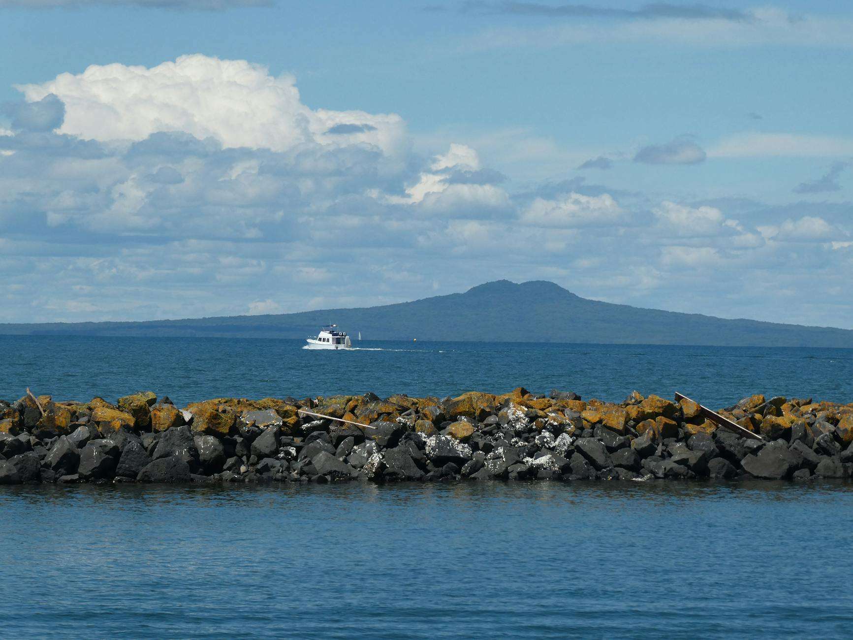
Rangitoto Island rose from the sea in two eruptions approximately 600 years ago, making it the youngest and largest volcano in the Auckland Volcanic Field — and the most symmetrical. Fullers360 runs a 25-minute ferry from downtown (≈$45 return, departures roughly every 2 hours in summer). The Summit Track takes most visitors 1 hour up and 45 minutes down to a 260m crater rim with a 360-degree view covering the entire Hauraki Gulf, the Coromandel, and on a clear day, Great Barrier Island. From the summit, a 30-minute detour leads through a series of lava caves — bring a torch.
What’s unique: Rangitoto is pest-free and the scoria fields support New Zealand’s largest pohutukawa forest, which explodes into crimson bloom from mid-December to early January. There is no drinking water on the island, no cafés, and no shelter from the sun; bring at least 2 litres per person and sunscreen regardless of season. The return ferry schedule is strict — miss the last boat (typically 3:45pm in winter, 6pm in summer) and you’re sleeping on lava. An alternative: the 4WD-towed Volcanic Explorer tour (≈$85) lifts you to the summit for those who can’t manage the walk.
Waitakere Ranges Regional Park: Auckland’s rainforest playground
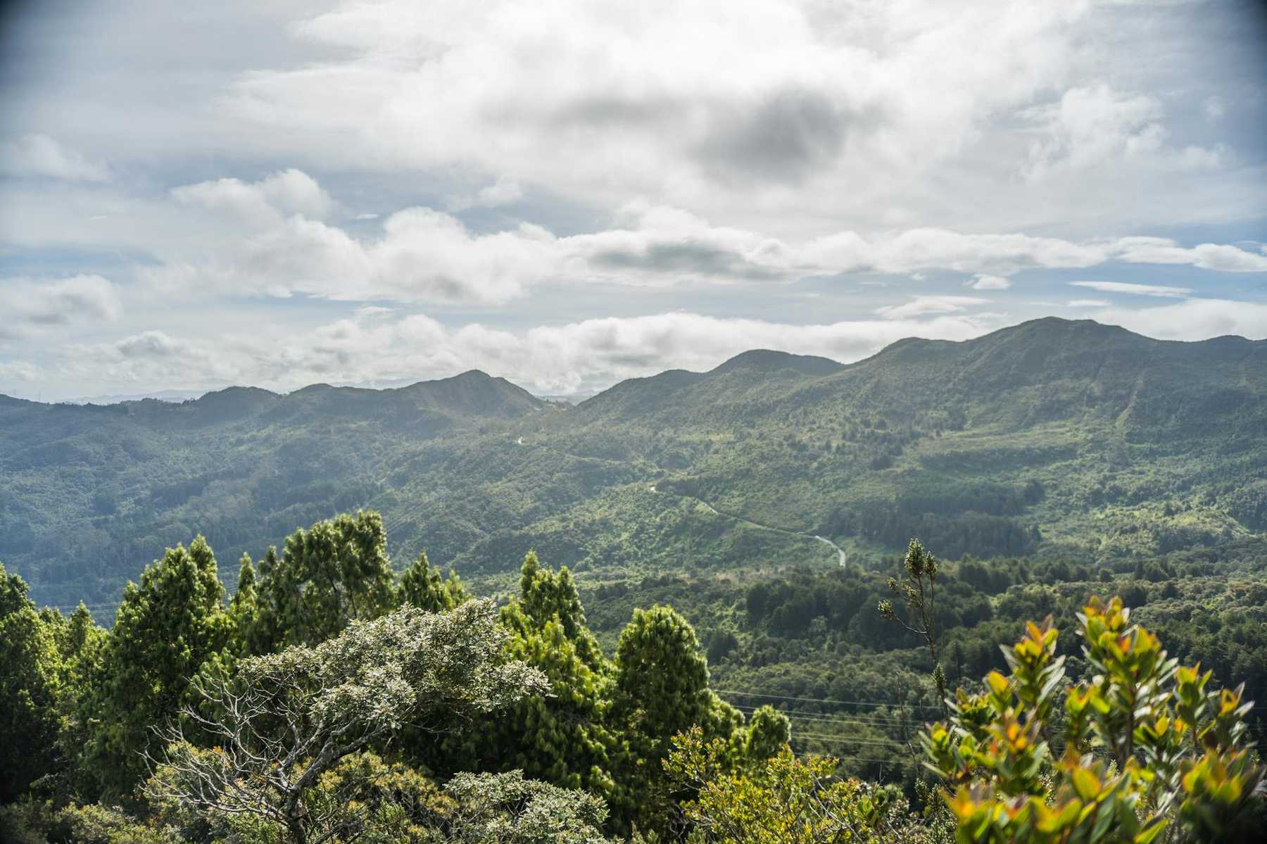
The Waitakere Ranges cover 16,000 hectares of dense subtropical rainforest directly west of the city. It’s where locals hike, and where many of Auckland’s best waterfalls, beaches and view-points sit. The bad news for 2026: Auckland Council closed most forested tracks in 2018 under a Controlled Area Notice to prevent the spread of Phytophthora agathidicida (kauri dieback), a soil-borne disease killing kauri trees. Some tracks have reopened on upgraded boardwalk; many remain closed. Always check aucklandcouncil.govt.nz for the current status of specific tracks before driving out, and use the cleaning stations at every track entry.
Currently open highlights include: Kitekite Falls Track at Piha (45 minutes one-way, boardwalked), Arataki Visitor Centre short loops (the centre itself is worth the drive for the panoramic terrace and the Maori whakairo carvings), Karekare Falls (5 minutes), the Mercer Bay Loop (1 hour, one of the best coastal cliff views in the region), and Whatipu Caves Loop (1 hour). The main Hillary Trail, an 80km multi-day through-walk, is mostly closed. Always carry rain shell and sturdy shoes regardless of the weather at the car park — the bush creates its own microclimate.
Volcano walks within the city
Auckland is the only major city in the world built on an active volcanic field — 53 individual cones scattered across the isthmus. Thirteen of them are public reserves you can walk, and they are free. The big four for visitors:
- Mt Eden (Maungawhau) — 196m, 10 minutes from the CBD, the highest natural point on the isthmus. The crater is sacred to Ngati Whatua Orakei — don’t walk into it. Sunrise and sunset here are iconic. Summit parking closed 2018; walk from Mt Eden Village (20 minutes up) or from the lower car park (15 minutes).
- One Tree Hill (Maungakiekie) — 182m, inside Cornwall Park. Drive to the summit or walk from the Cornwall Park entrance. Views over South Auckland and the Manukau Harbour. Historically the largest pa (fortified village) on the isthmus.
- Mt Victoria (Takarunga) — 87m, Devonport. Five minutes from the ferry. Small, easy, and gives you the best CBD skyline shot in the city.
- North Head (Maungauika) — 65m, Devonport’s other cone, riddled with WWII gun emplacements and tunnels you can walk through with a torch.
All four are walkable in under 45 minutes return. If you’re a view-hunter, do Mt Eden at sunrise, North Head at midday for the tunnels, and Mt Victoria at sunset — a full volcano day for the price of the Devonport ferry.
Waterfall and forest short walks
Beyond the Waitakere Ranges, two waterfall walks are worth building a half-day around. Hunua Falls, 50 minutes southeast in the Hunua Ranges, drops 30m into a clear swimming hole in summer. The 10-minute loop from the car park gets you to the main viewpoint; the longer Cossey Kingsway Track (2 hours) climbs to the top of the dam and returns via rainforest. Waitakere Dam Track, when open, traces a historic timber tramline through mature kauri — but check status; parts have been closed for kauri dieback since 2018.
For forest without waterfalls, the Te Rerenga (Long Bay–Okura) coastal walk is 5km one-way from Long Bay regional park, passing pohutukawa-lined cliffs and ending at the Okura estuary. The walk is easy enough for children; combine with a swim at Long Bay.
The Coast-to-Coast Walkway
A 16km urban hiking trail that crosses the isthmus from the Waitemata Harbour (Viaduct) to the Manukau Harbour (Onehunga). It links four volcanic cones — Albert Park, Mt Eden, One Tree Hill and Mt Cornwallis Hill — and gives you the best compressed understanding of Auckland’s geography in a single day. Allow 4–6 hours walking; break it into segments using bus routes 30 and 37 if you want to do it in two halves. Download the free map from Auckland Council before starting.
Water sports: surfing, kayaking, SUP, sailing
Surfing
Learn at Piha with Piha Surf School (2-hour group lesson ≈$90, includes board and wetsuit, book ahead for summer weekends) or Muriwai Surf School for slightly easier beginner conditions. Best beginner months are October to April; the Tasman stays cool year-round and you will want a wetsuit even in January. Advanced surfers head to Piha (left-breaking reefs either side of Lion Rock), Muriwai (long beach break) or up to Pakiri for less-crowded peaks.
Sea kayaking
The signature Auckland kayak is the sunset paddle from Okahu Bay to Rangitoto Island (Auckland Sea Kayaks, 6-hour guided trip ≈$180, includes summit walk). Shorter options: hire doubles from Takapuna Beach (≈$45/hour) to paddle along the gulf coast, or from the Viaduct to explore the Westhaven marina. Flatwater paddlers love the Puhoi River (3 hours from Puhoi village to Wenderholm Regional Park, seakayaks.co.nz runs guided trips).
Stand-up paddleboarding
SUP rentals operate at Mission Bay, Takapuna, Mairangi Bay, Orewa and Omaha. $25–$35 per hour. The most photogenic SUP spot is Browns Bay at high tide, with Rangitoto on the horizon. For absolute beginners, the Omaha lagoon is completely flat and safe for kids.
Sailing
Auckland is the City of Sails for reason — there are more boats per capita here than any other major city on Earth. The classic tourist experience is a 2-hour skippered sailing trip on the Pride of Auckland (departs Viaduct, ≈$90) or an America’s Cup yacht sail aboard NZL 40 or NZL 41, the actual 1995/2000 Cup boats (≈$175, 2 hours, you help grind). Bareboat charters are available on Waiheke and in the Bay of Islands but require a skipper or a ticket.
Adventure and adrenaline
SkyJump and SkyWalk from the Sky Tower
The Sky Tower’s SkyJump is an 11-second, 85kph base-jump-by-wire from 192m up, landing on the plaza below ($355, over 16s, weight limits apply). The SkyWalk is a 1.2m-wide external platform 192m up that you walk around with a guided harness ($195). Both include Sky Tower observation deck entry. Book online in advance; same-day slots are rare in summer. These two are the most famous adrenaline activities in Auckland and genuinely worth it — the view alone is incredible, the jump is the icing.
Auckland Bridge Climb and Bungy
AJ Hackett Auckland runs the 1.5-hour Bridge Climb up the Auckland Harbour Bridge ($155) — 65m above the water, unrestricted city views. The Bridge Bungy ($185) drops you on a long rope from the middle of the same bridge, either dipping in the Waitemata or stopping above it. Both depart from Westhaven.
Canyoning in the Waitakeres
AWOL Canyoning runs full-day trips down the Piha Canyon (intermediate) and Blue Canyon (beginner), abseiling waterfalls and sliding natural rock chutes through native bush ($245–$295 including transfers from Auckland CBD). Runs year-round but best October–April. This is the single most distinctively Aucklandish adventure available — volcanic basalt canyons in a rainforest, 45 minutes from downtown.
EcoZip Adventures on Waiheke
Three 200m flying foxes above the Waiheke canopy, plus a 1.4km bush walk down ($159). Included in some day-trip packages from Auckland. Family-friendly from age 6.
Whale and dolphin watching
Auckland Whale & Dolphin Safari runs 4.5-hour expeditions into the Hauraki Gulf year-round ($175, departs Viaduct). Regular sightings of common and bottlenose dolphins, Bryde’s whales (rare in any other city’s waters), orca (October–January), and occasionally blue whales. Binoculars and lunch provided; it is New Zealand’s only year-round city-based whale operation.
Wildlife encounters
The Auckland region is unusually wildlife-rich because Hauraki Gulf islands have been systematically cleared of predators over the last 30 years. Beyond the Muriwai gannets and Goat Island snorkelling, the other essentials:
- Tiritiri Matangi — 75-minute Fullers360 ferry into an open sanctuary with kokako, takahe, tuatara, kiwi (rarely seen in daylight), and dozens of species impossible to see on mainland Auckland. Day trip ≈$120 including guide. Covered in more detail in our day trips guide.
- Kelly Tarlton’s Sea Life Aquarium — underwater tunnels through shark and stingray tanks, plus the only sub-Antarctic penguin exhibit in the Southern Hemisphere. On Tamaki Drive between CBD and Mission Bay ($45 adult).
- Auckland Zoo — 135 species, strong focus on NZ natives including kea, kiwi, tuatara (Western Springs, $29).
- Shakespear Regional Park — 45 minutes north, a predator-fenced headland where pukeko, takahe and kaka roam free on grassy hillsides next to sandy beaches. Free to enter.
What to pack for an Auckland outdoor day
The single most-quoted line about Auckland is “four seasons in one day” — and whoever coined it wasn’t joking. Standard outdoor day kit: lightweight rain shell (even if the forecast says sunny), layered clothing because the harbour is 5–8°C cooler than downtown at midday, reef-friendly SPF50 sunscreen (NZ’s UV index is brutal even on cloudy days — the ozone layer here is genuinely thinner than the Northern Hemisphere), 2L water per person, insect repellent in summer (sandflies at Bethells, mosquitos in the Waitakeres), and closed-toe shoes for any track with kauri-dieback cleaning stations (you must scrub). For west coast beaches specifically, add a hat — there is essentially no natural shade.
Seasonal timing: when to visit which beach
Auckland’s beach season peaks January–February when sea temperatures reach 20–22°C. Water is swimmable from mid-November to mid-April at the harbour beaches; west coast water never gets warm, so wetsuits in October–November and in April are essential. Winter (June–August) is not a beach-swimming season but it is excellent for dramatic Piha walks, storm-watching at Muriwai and whale-watching in the Gulf (humpbacks migrate through in June–July). Spring (September–October) brings the best weather-to-crowd ratio at all beaches. The gannet colony at Muriwai is most active August to early December.
Accessibility on Auckland beaches
Mission Bay, St Heliers, Takapuna, Orewa and Long Bay all have sealed accessible promenades that reach the sand edge; beach wheelchairs can be borrowed free at Mission Bay and Takapuna (contact surf clubs in advance). Piha, Karekare and Muriwai have sand-only approaches that are not wheelchair-accessible beyond the car park. Rangitoto Island’s summit track is unsealed scoria and not suitable for wheelchairs; use the Volcanic Explorer tour for accessible summit access.
Dog-friendly beaches
Auckland Council operates a seasonal dog-access schedule. In summer (Labour Weekend through end of March), dogs are banned from most city beaches 10am–6pm; off-leash morning and evening. Designated year-round off-leash beaches include Cheltenham (Devonport end), Brown’s Bay north end, and Mairangi Bay south end. Karekare is dog-friendly off-leash year-round north of the stream; Piha requires leashes in summer. Always check the signage at the beach entry.
Sample 2-day outdoor itinerary
Day 1 — East Coast and Volcanoes. Early morning: sunrise at Mt Eden (free, 15-min walk). Breakfast in Mt Eden village. Mid-morning: Rangitoto ferry from downtown, summit walk, lava caves. Lunch on the ferry back. Afternoon: Devonport ferry, Mt Victoria, North Head tunnels. Sunset swim at Cheltenham Beach if the weather allows. Dinner in Devonport village. Night ferry back to the CBD.
Day 2 — West Coast and Waitakeres. Morning: drive via Scenic Drive to Arataki Visitor Centre (panorama terrace). Continue to Piha by 10am. Kitekite Falls walk (1.5 hours return). Lunch at the Piha Café (limited — or packed lunch). Afternoon: drive 10 minutes south to Karekare; short walk to Karekare Falls, then time on the beach. Return via the Mercer Bay Loop for the sunset cliff view (1 hour). Dinner back in the city at Ponsonby or Karangahape Road.
Frequently asked questions
Can you swim at Piha?
Yes, but only between the red-and-yellow flags and only when the Piha surf club is patrolling (roughly 10am–6pm, late October to early April). Outside those times, do not enter the water above your knees. Piha has permanent rip currents that have caused multiple drownings, including experienced swimmers; this is the single most important safety rule in this guide.
What’s the difference between Auckland’s west coast and east coast beaches?
The east coast faces the sheltered Waitematā Harbour and Hauraki Gulf: calm, golden-sand, swimming-friendly, and lined with cafés. The west coast faces the open Tasman Sea: big surf, black iron-sand, wild scenery, strong rips, and minimal facilities. Most visitors want one of each. The east coast for a swim; the west for the landscape.
Are Waitakere Ranges tracks open in 2026?
Partially. Auckland Council has reopened many shorter tracks after boardwalk upgrades, including Kitekite Falls, Karekare Falls, Mercer Bay Loop and most of the Arataki centre tracks. Many forest trails in the interior of the park remain closed under a Controlled Area Notice to protect kauri from Phytophthora agathidicida. Always check aucklandcouncil.govt.nz for track-specific status before driving out, and use cleaning stations at every entry.
Where can I snorkel near Auckland?
Goat Island Marine Reserve at Leigh is the best shore-based snorkelling within easy reach — clear water, abundant fish, and gear hire at the beach. Tawharanui Regional Park has a small marine reserve with similar (quieter) conditions. Beaches inside the harbour (Mission Bay, St Heliers) have murky water and few fish.
What’s the best beach for young children?
Cheltenham Beach (Devonport) for shallow calm water plus easy ferry access; Long Bay Regional Park for space, playground and BBQs; Takapuna for volume of amenities; Omaha Lagoon for absolute flat-water safety. All are east-coast harbour beaches.
What’s the best beach for surfing?
Piha for the most reliable waves and the biggest scene; Muriwai for longer beach-break peaks and fewer crowds than Piha; Pakiri for empty breaks and beginner conditions. Omaha Bar has good rights at mid-tide for shortboarders. All require wetsuits year-round.
How long is the Rangitoto summit walk?
About 2.5 hours return from the ferry wharf, 5.5km total, 260m of elevation. The surface is uneven volcanic scoria — sturdy shoes required. Add 30 minutes for the lava caves detour near the summit. Plan for a 4-hour total Rangitoto day including ferry times.
Can you see the gannets at Muriwai all year?
No. Australasian gannets (takapu) are at Muriwai from mid-August through March. Peak activity with chicks is November–February. By April the colony has left for Australia; the cliffs are empty June–July.
Is the water warm enough to swim in Auckland?
Depends on the coast. Harbour beaches reach 20–22°C in January and February, 17–18°C in November and April, and drop to 13–14°C in winter. The Tasman west coast is 2–3°C cooler year-round. Most visitors swim unassisted from December to March on the east coast; west coast surf requires a wetsuit regardless of season.
What’s the best volcano hike in the city?
Mt Eden (Maungawhau) for the highest, most accessible isthmus summit and the best 360° city view; One Tree Hill (Maungakiekie) for pa history and South Auckland views; North Head (Maungauika) for the tunnels and the best CBD skyline photo. All are free, all are under an hour return, and all are reachable by public transport.
Putting it all together
No other major city lets you surf a volcanic black-sand beach and walk a 600-year-old volcano summit and snorkel with kingfish in a marine reserve in the same long weekend. The practical tricks are: always check safeswim.org.nz on the morning of a beach day, always check the Waitakere track-closure list before driving west, always pack a rain shell, and always respect the flags. Do those four things and Auckland’s outdoor hit rate is among the highest of any city on the planet.
If you want to expand beyond the region’s core beaches and outdoor spots, our day trips from Auckland guide covers longer excursions like Waiheke Island wineries, the Coromandel peninsula beaches and Hobbiton. For getting to west coast beaches without a car, see getting around Auckland. For planning your base in the city, our neighbourhoods guide helps you choose between the CBD, Ponsonby, Devonport and the beach-side suburbs.